
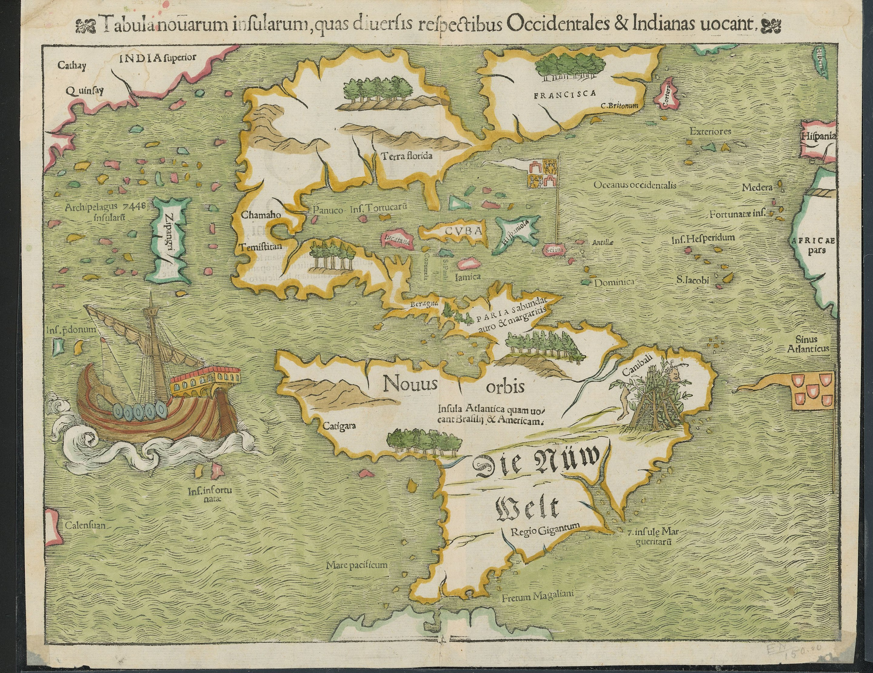
Now I really want to see an animation of what the European discovery of the planet looked like. Imagine a time lapse of a Civilization game, as the map is slowly revealed. I want to see that, except actual history.
Also make the map shape and style match that times maps.
Anyone know what Zipangri is? Could that be Baja California, or what?
Edit: Japan. Is apparently just off the coast of Mexico
This makes sense given the popular knowledge at the time. The reason Columbus set sail wasn’t because he was a genius that knew the Earth was round when everyone else didn’t. We knew the Earth was round since antiquity. I can’t remember who1, but some ancient Greek had calculated the circumference of the Earth using the angle of a shadow, distance to a
equinoxsolstice, and simple trigonometry. They guy was less than 5% off with his rudimentary calculation, which is impressive considering that he paid some dude to measure the distance between two towns by walking it. Anyways, the Western Europeans thought that Japan was farther east, somewhere around where the words “Terra florida” are on this map if I recall correctly from memory. When the Niña, Pinta, and Santa Marimba (party boat! jk, it was Santa Maria named after the “virgin”) landed on the most beautiful land that human eyes had ever seen, they knew they hadn’t landed on Zipangri/Cipangu/Japan. Instead, they thought they had landed on some island off of India, which is why they called the locals “Indios” (Indians). Anyways part 2, they thought that Japan was much further east than it was. I imagine that since they hadn’t found it for this map yet, they though it must be right out of sight of the western coast of North Vespucci (America).What I’m curious about is that 7448 inflating archipelago. Anyone have an idea on what that’s about?
1: The dude was Eratosthenes. Thanks, @user134450@feddit.org!
Santa Marimba
I’m stealing this! 😂
lol, I updated it with a silly link for more even fun 😋
It’s not “inflating”, it’s “insularum” (they also used to use the tilde as a shorthand for m and n), using the old long s
The El Niña weather event, the Piñata and the Santa Claus.
perfect! 😆
I’m not an avid reader, but I’m a huge fan of a book called Over the Edge of the World by Lawrence Bergreen. That detailed Magellan’s voyage around the world. A few takeaways:
-
Spices really were the thing everyone in Europe wanted. If a sailor managed to smuggle a backpack full of cloves, it would be enough to buy a modest house. Only one of 5 ships made it back, but it was filled with top quality cloves and that was enough that the trip was STILL a financial gain.
-
Nobody really knew where the spices came from. India was a nebulous semi-mythical place, and some believed there were a few "India"s
-
Magellan, while Portuguese by birth, basically moved to Spain when Portugal wouldn’t pay for him to try to find the spice Islands
-
The treaty of Tordesillas roughly divided the new world between Spain and Portugal. The land east of whatever meridian was Portugal’s, and west was Spain’s. But there were still issues, like longitude not really being measurable at the time and no clear idea who had claim 180° past that meridian. But it would have been to Spain’s benefit to find the spice islands past that meridian
Bonus fact: the first human to sail around the world was Magellan’s slave, Enrique (last name escapes me). He was brought from Indonesia(?) to Europe, then set sail on this round-the world journey, eventually going near his native homeland. Magellan had it in his will that Enrique be freed upon his death, but when he was killed on that voyage (basically by his own who) nobody was aware of that.
-
Apparently Japan’s shape wasn’t well known either
I had guessed it was Sri Lanka since it is also shown just off the coast of India. Then I figured it was more likely Indonesia given it’s surrounded by so many other islands and not that close to India. But yeah, now that I know that the name meant Japan I’m wondering if it’s depiction on the map is a conflagration of accounts of Indonesia and Japan.
Given the lack of shape, it could be just about anything - I wonder if it was one report, or hearsay with no details and they filled in something
They were generally working with very, very rough, incomplete, conflicting, or confusing info, yes.
It’s pretty astounding to me that this is even remotely as accurate as it is.
That explains the pearl harbour
Before seeing your comment and searching myself, I wondered if it was California as well, since it was thought that California was an Island for some time.
cuba has always been cuba?!
I’m guessing the Taino called it something else.
Looks like they called it Cuba
either “great place” or “where fertile land is abundant”
So…first impressions pretty positive?
FWIW, this gives a somewhat different origin, although says it is derived from the local name.
ha, good point. i was just kinda shocked to see a legible ‘cuba’ and ‘florida’
Terra florida means something like “land with many flowers” in Spanish.
IIRC their word was something like “Kolba”
I really really want to find a good book or website showing the extended evolution of maps of the world or specific areas. This stuff fascinates me.
I’ve found a few minor ones over the years, but never a good one.
Sort of map-related, but the Longitude series/book is pretty fascinating. This map was drawn without really being able to calculate longitude except by dead reckoning.
I absolutely love wildly inaccurate old maps. They have so much charm.
is it inaccurate? I just see the state of Texas and from what I’m told it’s bigger than then the northern hemisphere.
So are we not gonna talk about the whole area labels for cannibals?
We are now.
What’d you want to talk about?
Do clowns really taste funny or nah?
And how many wipes do they need after dumping their girlfriend?
Ships were huge in the 1500s!
Where’s the dragons tho?
You have to Imagine them.
They be here.
We are the dragons
How in sam hill are their vowel Vs and consonant Us in this‽
The water is colored green. Took my mind a bit of time to realize the land is water and the water is land
Probably azurite paint aging. Turns green (Edit: forgot to mention because it turns into malachite) over time and was super common Europe.
It’s why a ton of Renaissance art has greens where you’d expect blues
Musta been a cold day in North America.
i like how our boi did highlighter colors.
superior india is just right of china. probably quinfay there is “shanghai”.
there’s also that canibali place with bush tents hung with a leg and a happy face.
Obviously the green part is the ocean.
Pretty good map for the 16th century anyhow, except India being where Russia would be
“India” did not mean then what it does now.
Man what a shit map, they are horrible at cartography /s
This dumbass didn’t even know the Maps app is free.
The only label on the map that’s both on Latin and in old German.


